The objective of the preliminary assessment is to investigate the damage to the starboard side of the ship, which were first shown in the Discovery Network film released in 2020, and to determine whether the new information gives reason to revise the conclusions drawn in the 1997 report of the Joint Accident Investigation Commission of Estonia, Finland and Sweden (JAIC).
When conducting investigations, it is crucial to ensure the transparency and factual accuracy of these operations. We need to be delicate and respect both the memory of the victims and the ongoing grief of their loved ones. Safety investigation authorities are not searching for culprits, but trying to identify the causes of accidents in order to prevent similar incidents from happening.
Estonian Safety Investigation Bureau
Estonian Safety Investigation Bureau (ESIB) is permanent and independent body under Ministry of Economic Affairs and Communications. The objective of ESIB is to improve transportation safety through professional and independent investigation of accidents and serious incidents in maritime, aviation and railway sector.
Swedish Accident Investigation Authority
The Swedish Accident Investigation Authority (Statens haverikommission, SHK) is an independent governmental authority under the Ministry of Justice that investigates all types of serious civil or military accidents and incidents with the aim of improving safety, regardless of whether they occur on land, at sea or in the air.
read more
Finnish Safety Investigation Authority
The Safety Investigation Authority, Finland (SIAF) is a Finnish safety investigation making authority, which operates in connection with the Ministry of Justice. The purpose of the safety investigation is to promote general safety and to prevent any new accidents from occurring.
read moreInternational investigation team
The preliminary assessment of the wreck of M/S Estonia and the surrounding seabed is led by the Estonian Safety Investigation Bureau.
The international team of the preliminary investigation in the summer of 2021 included Estonian and Swedish marine and geological experts, including Sten Suuroja, head of the Department of Marine Geology and Geophysics of the Geological Survey of Estonia (GSE), Martin Jakobsson, Professor of Marine Geology and Geophysics of Stockholm University, and Brian Abbot, a 3D scanner specialist from the USA.
A number of experts were consulted during the preparations of the preliminary assessment, including the Marine Accident Investigation Branch (MAIB) of the United Kingdom.
In March 2021, the preliminary assessment project and the planned preliminary studies were presented at the meeting of the Marine Accident Investigators’ International Forum (MAIIF).
Surveys in 2021
Between 8 and 16 July, the Estonian Safety Investigation Bureau, the Swedish Accident Investigation Authority, and the Safety Investigation Authority of Finland, led by the Estonians, conducted a preliminary assessment of the wreck of the passenger ferry MS Estonia and the surrounding seafloor.
The pre-survey was carried out by the Estonian multipurpose icebreaker EVA-316 and the Swedish research vessel Electra af Askö. The main purpose of the pre-survey was to examine and document the ship’s position on the bottom and the area’s sea bottom. Different kinds of sonar instruments, such as multibeam and sidescan sonar were used. The ship was filmed by using a ROV (remotely operated underwater vehicle).
Surveys in 2022
- Photogrammetry survey
- Laser scanning
After the preliminary assessment, a detailed analysis of the gathered information was carried out, which will be the basis for further investigation. An exact 3D model of the wreck was be made using the photogrammetry survey.
Surveys in 2023
During the marine works in July 2023, bedrock and fouling samples were acquired from near the hole in the starboard side of the hull. Cut-out pieces of the port side plating, which were cut out by divers in 1994 in order to examine the interior of the wreck, were recovered. It was also possible to cut out and recover a steel sample from the damage of the starboard side and recover parts of a cabin window glass and seal. The car deck, including the visor and ramp control panel, located next to the car deck entrance, were inspected with an ROV. The hole of the starboard side was filmed with the ROV from outside the hull as well as from inside through the car deck. The bow ramp of MV Estonia was recovered from the seabed. In November 2023, a high-resolution seabed imaging survey at the wreck site of MV Estonia was completed.
Surveys in 2024
This survey was the follow-up survey for the high-resolution seabed imaging sonar survey conducted in November 2023. About 300 presumably man-made objects were detected and located by the sonar survey in the area of the proposed sinking tracks of MV Estonia. The purpose of the follow-up survey was to identify the detected objects seen on the sonar image, verify whether these originate from MV Estonia and from which part of the vessel, if possible.
The wreck and its surroundings
With a 3D scanner and an underwater robot, we detected damage to the hull plating on the starboard side of the ship, which was partly shown in the film released by Discovery Networks in 2020. The damage covers an area of at least 4 metres wide and 22 metres long, but the exact extent cannot be ascertained, as the damage is partly located under the hull. The damage is on the outer plating, but also transfers to the ship's internal structures. We also found damages to the port side and stern of the wreck.
Further investigation and calculations are needed to determine the exact cause of the damage detected so far. The hinges of the vessel’s bow ramp are broken or deformed, the bow ramp itself has detached from the vessel, and the car deck is open. The following studies and analyses will also reveal what caused the bow ramp to detach from its stationary fastenings.

Underwater Robot Surveys (ROV)
Work was performed in the stern part of the wreck to determine the position and condition of the stern ramps, the condition of the rudder blades and propellers, and the mudline in the stern part. During the works it became clear that the stern ramps are in the closed position: 15.55
No damages were discovered on the outer sides of the stern ramps. The lower right stern corner of the hull is partly inside the ground.
One can see a fairlead with rollers and gravel used for wreck covering works: 21.13
One can see a geotextile or a detail of the superstructure lying on the seabed behind the stern (pictured on the right): 22.23
Both rudder blades were on the starboard: 30.14 and 38.14 No damages were identified.
Both propellers are without any visible damages. The propeller blades are in neutral position: 31.40
The survey continued on the starboard side of the wreck, moving near the mudline towards the bow: 44.20
Because the first dive was performed higher (most of the hull damage on the starboard side is below the hull curvature), the hull damage on the stern side is not visible.
The starboard stabilizer fin was inside the hull (not in the extended position): 55.00 The reinforced board part surrounding the stabilizer fin is more corroded than rest of the hull and the welds are covered with a thick layer of rust.
1.05.08: The movement went along the seabed, and a rupture and a crushed spot opposite a pink corner of granite was observed, that had initiated the entire survey.
Next it was headed upwards to the port side (1.25.00), where the condition of the centre part of the flat bottom of the vessel and an inlet on the port side cut into the hull (1.35.34) during the diving survey in 1994 was observed, and the metal truss that was used to close it with a cut-out piece of the hull.
From the port side it was descended to the mudline (1.49.30) and the movement continued moving towards the bow.
1.55.31 the starboard anchor was reached above the seabed and immediately behind it (1.55.56) a bow ramp resting on the front part of the vessel came visible.
End of recording: 2.00.01
The ROV descends 09.59 in the middle of the wreck under the bilge keels on the curvature of the port board.
16.27 The ROV moves towards the stern and at 18.00 reaches the second major damage above the granite rock. It turns out that the larger robot (1 m x 0.6 m x 0.5 m) does not fit close to the damages, because the space next to the curvature of the wreck is narrowing, and in some places the width of the gap is less than 0.5 m.
22.52 Moving towards the bow, it reaches the previously seen rupture, viewing it and ascending, it reaches under the bilge keel of the starboard.
26.43 The difference in height between the rupture and the bilge keel is observed until visibility is lost due to sediment uplift.
We proceed towards the bow until the bow thrusters visible from the starboard side: 43.43
50.34 The bow is reached, where the bulbous bow is observed from the right and forward.
52.40 The upper part of the bulbous bow is visible.
54.06 One can see the front part of the bow stem with a locating horn and the former location of the bottom lock (Atlantic lock) of the visor on the forepeak deck (visible weld marks of the lock removed by the divers) and the access hatch of the forepeak deck (manhole).
54.22 A fragment of the corner of the bow ramp attached to the starboard hinge of the bow ramp comes visible.
55.06 A closer look shows how the stiffeners, plating and welds are torn on the fragment. Next to the longitudinally hanging longitudinal stiffener, one can see a strip of torn and rolled steel plate.
56.26 The robot moves away for a moment to check that the cable is payed out, and when moving back, it reaches the left hydraulic cylinder of the bow ramp and the left side locks of the visor. The left hydraulic cylinder of the bow ramp is in its bed.
When descending again under the starboard (59.10), it moves for a moment away from the bulbous bow to make sure that the ROV cable is not trapped because it does not pay out so easily – the reason is that the cable’s descending place is too far from the bow ramp, although the EVA-316 has moved closer in the meantime.
1.03.30 Back again next to the draught marks on the starboard side of the bow and descending to the bow ramp: 1.06.32
1.08.05 The hinge lugs of the bow ramp are being observed, moving from top to bottom, i.e. from the left side of the normal position of the ramp towards the right side. It can be seen that both of the lugs of the hinges on portside are strongly deformed, the lugs of the second hinge from the left are broken/torn.
1.08.47 Two hinges on the starboard side are missing (torn off with the corner of the ramp).
1.10.38 Observing at the central part of the bottom of the ramp, strong deformations and twisting of the stiffeners can be seen in directions of both sides. On the main stringers of the bow ramp there are triangular indentations on the hinge side which appear to correspond to the triangular contour of the forepeak deck.
1.23.49 We are observing a fragment of the ramp attached to the hull from inside outwards. One can see a hinge cover plate hanging down.
1.24.00 When descending, one can see the deformation of the inside edge of the ramp tunnel, probably caused by the hydraulic cylinder on the starboard side of the ramp.
1.24.22 A fragment of the ramp can be seen again, and more clearly the edge rupture.
1.25.38 The ROV attempts to move to the car deck. At a distance of about 10-15 meters inside the car deck, the cable is trapped at the front of the bow ramp and the ROV does not get any further. One can see the rear doors on the car deck, which have disintegrated on the ceiling of the car deck (the wreck is upside down), probably due to breakdown of a van and the different materials mixed in a pile, packaging and boxes.
As the cable does not pay out, we turn the ROV around and exit, observing the ceiling of the ramp tunnel, where various pipelines and cable bundles can be seen.
1.33.51 An attempt is made to enter more along the corner of the deck level of the starboard car deck (now above). We reach about the same distance, 10-15 meters inside the car deck. The cable doesn't pay out. Same picture: different packaging, materials mixed in a pile.
Conclusion: It is possible to enter the car deck, but for this the base vessel must be positioned exactly in front of the bow opening so that the cable does not run over the corners of the bow opening. It would probably be easier to do this with a smaller drone that does not pick up the gentle sediment with a strong stream of water.
1.35.34 The ceiling of car deck tunnel.
1.41.23 When rising back to the port board, we find ourselves in a field with sand waves. Despite a depth of more than 70 m, the storms have created wave patterns on the sand deposited on the hull.
1.42.28 End of recording.
A drone was used because it was necessary to observe the condition of the mudline as closely as possible across the entire starboard side of the wreck.
The drone reaches the central part of the flat bottom of the vessel at a depth of 66.6 m: 02.14
We descend and go to the mudline on the stern side of the stabilizer and immediately come to the stern side damage described earlier: 6.01
We take a closer look at it at a depth of 79.6 m. Without fully pushing the device for now. We move towards the bow so much under the edge as the main light (which is under the drone) allows us to. Immediately below the edge, one can see that the entire part against the hard bottom is deformed: 08.54 and 09.46
We continue to move to the bow until 20.54 we reach the anchor.
Where was the bow side damage? We turn around and move back towards the stern. When moving under the side fender, it is possible to understand how narrow and deep the recess narrowing under the wreck hull is at a depth of 85.8 m – under the bow part of the fender it is about 0.5 m wide: 21.33.
Even for the drone, the space starts to become too narrow. We ascend one meter: 21.40 We move on the side fender towards the stern at a depth of 84.4 m: 22.28
23.34 The open chock (fastening device) above the side fender at a depth of 84.7 m and 3-4 m towards the stern of the bottom rises sharply: 24.08
Smaller, approximately 50 mm outlet at a depth of 82,6 m, 1 m below the normal position of the side fender: 24.44.
25.03 Even steeper ascent and rupture in bow side. One can see a stronger base and the slope of the moraine layer on it.
The rupture runs through the hull at a depth of 82.2 m from the 50 mm outlet. The central part of the rupture and the torn beam at a depth of 83.1 m.
We push the drone into the opening and see the frame and axle of a truck turned upside down on the car deck 27.43
The rupture opening has been formed exactly at the level of the car deck.
We are ascending along the rupture crevice, and measure the depth of the upper part of the crevice to be at 81m: 31.07
There is a starboard stabilizer near the rupture: 32.12, under which we detect hull deformations: 33.52.
34.56 Back next to the stern damage.
40.32 We are waiting for EVA-316 to follow us towards the stern
41.42 We move along the seabed towards the stern corner of the starboard side.
There seems to be softer soil under the stern side of the hull and no deformations are visible: 45.45
49.51 We reach under the stern corner at a depth of 76.4 m
52.53 We observe the stern corner and stern extension attachment. The hull is slightly dented, but there are no major damages.
54.33 We start to go up as the drone's battery level is less than 20%.
We continue with Falcon ROV on the port side of the bow corner of the forecastle: 11.02.
11.17 We are observing a window hole cut wider by divers in 1994.
16.03 We descend under the edge next to the fairlead with rollers on the port side of the bow and carefully to the attachments of the bow visor.
19.34 By the anchor windlass of the port side.
20.39 By the hinge bolt of the port side, which is still there, but sunk to the starboard side. We continue descending and 21.52 we can see that the starboard hinge attachment is close to the ground. Due to the surrounding masts and ropes, we will not take the ROV any deeper. The sand layer covering the bottom has sand waves.
24.51 We ascend and head around the edge to the forward bulkhead.
25.17 Locating horn of the visor on port board.
28.18 Bow bulb from the left side.
31.41 Fragment of a ramp attached to the hull.
34.10 Ramp
46.22 We ascend to the thruster holes on the starboard and observe them also from the left.
53.22 The visibility at port side openings is limited and we move back to the left front where the deposited sand also has waves: 55.27
1.01.52 End of recording.
At the bow of deck 6 on the port side: 05.33
07.03 A window cut wider by the divers on deck 6 with the grilles that have been in front of it.
07.11 Left wing of the bridge
08.29 Bridge windows
13.09 We continue moving towards the stern along the edge of deck 6.
21.03 H-beam section lying on the edge of the deck
22.43 Larger windows without glazing
24.49 Left side passenger corridor door opening closed by divers.
28.35 A window with bars
29.17 Deformation and cracks near the edge of the deck
29.50 A window with bars
30.09 Deformation and cracks near the edge of deck 6
30.50 Deformation and cracks continue
31.20 Deformation and cracks
32.47 Deformation and cracks
34.40 Same
39.45 Visibility significantly better as we ascended: 68 m
40.50 The pillar of the stern mooring deck on the port side is open and its deck beams are clearly deformed.
48.10 A rupture in the stern corner of deck 6.
49.11 Sediment can be seen in the lower rooms of the stern.
49.50 Stern ramps
53.11 Soil under the stern
59.59 Stern extension (duck tail) with trailing edge
1.03.48 Name “Estonia“ on the board
1.04.45 Mesotech sonar
1.06.20 The ROV cable gets stuck behind the Sonar and the dive must be stopped.
Using a drone, we measure the location of damages on the starboard side of the hull.
02.44 The Mesotech sonar is positioned exactly against the bow edge of the starboard stabilizer. We measure the distances from the front edge to the bow side rupture: 4.6 m, and 17.4 m until the end of the stern damage.
The total area is 22 m – as much as it is possible to penetrate below the edge.
21.10 We look in again with the drone from the bow side rupture at a slightly different angle and we see another bus lying on the car deck on top of a truck (visible a part of the bus wheel and side cavity).
26.13 Right in front of starboard bilge keels of stern. We are observing the kingston grids, because the result was unclear in the sonar image. No damages are detected.
29.0 End of recording.
Using a drone, we check objects around the wreck: 00:54
A frame with lifting eyes lying on the seabed north of the bow of the wreck. Is this something that Rockwater used during the first time?
In addition, we checked the boxes found near the wreck. It's a box of white plastic, probably a life jacket box.
05.44 Probably a fragment of the liferaft frame?
06.44 Ascent and end of recording
Seabed survey
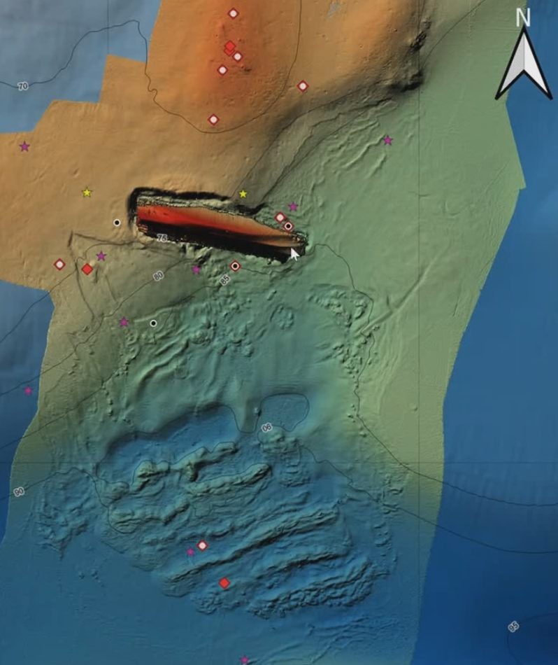
The Estonian Geological Survey performed a seismoacoustic profiling survey on Stockholm University’s research vessel Electra af Askö. This method enabled the team to study the cross-section of the seabed down to the hard rocks of the bedrock. The gathered data show that the bow and stern of the wreck rest in soft clay and that the centre of the ship is lying on a ridge with a harder bedrock – probably granite. The conclusions so far have been drawn on the basis of data obtained by indirect methods, and in order to draw more precise conclusions, it is necessary to study the wreck and the seabed more thoroughly by means of modern technologies.
Last updated: 06.09.2024